
‘Beast from the East II’ hits UK with ice and snow
Heavy snow has begun falling in southern and eastern England, with gale-force winds and “blizzard” conditions set to batter the same parts of Britain later today as the so-called Beast from the East II sweeps in from Scandinavia and Russia.
Eastern and southern England will be affected the most though there are yellow weather warnings for snow and ice across the length of Britain, which will remain active until around midday on Wednesday. A more serious amber warning, set to last until Monday, is in place for Norfolk, Suffolk, Essex and Kent.
The Met Office said easterly winds as strong as 40mph could lead to “blizzard conditions”, where lying snow will blow and drift.
It comes as a result of bitter easterly winds from Europe combined with a weather front named Storm Darcy by the Dutch meteorological office.
Swathes of Scotland and northeast England have also already seen snow, with forecasters projecting these areas could see anything from 2-5cm and 10-15cm in regions above 200m.
Snow falling heaviest in eastern England, Met says
The heaviest snow is now falling in eastern England, the Met Office has said in it latest update, which you can see here:
Sam Hancock7 February 2021 14:20
Snow to affect Britain until mid-February, graphic shows
WXCharts, a data-led weather forecaster, has released a graphic that shows wintry rainfall and snow hitting parts of Britain until at least 13 February.
While snow will not fall constantly in that time, according to the animation, it paints a pretty bleak picture of what is to come over the next six to seven days.
It points to the aftermath of Storm Darcy being felt for longer than initially thought.
According to the forecast, the current conditions in the southeast will slowly move over to the Midlands and further north by Tuesday – at which point there will be little to no snow falling across the country.
But on Friday (12 February), a significant amount of snow will move from Northern Ireland over to Wales, into the Midlands and central England, even stretching to parts of the northwest. On the plus side, it seems as though the amount of snow falling is not likely to exceed around 4cm.
The conditions are forecast to clear up by Saturday, leaving much of the country both snow and rain free for a couple of days.
You can view the graphic here, as well as a screenshot of it below:
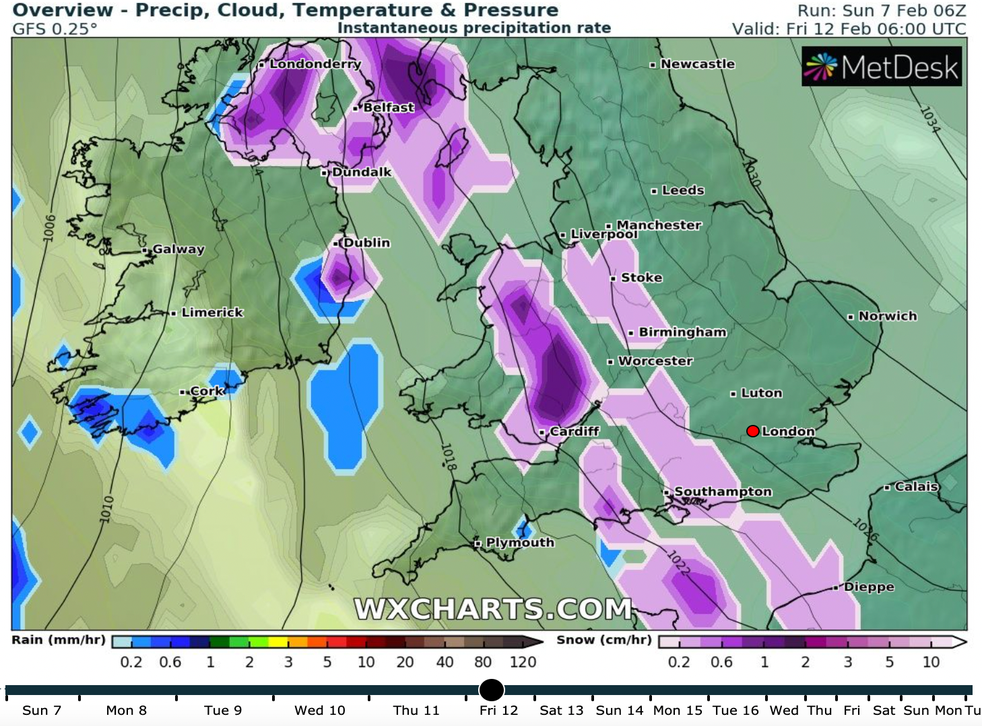
(WXCharts)
Sam Hancock7 February 2021 13:43
Met: ‘Bitterly cold easterly winds’ to make country ‘feel sub-zero’
It looks like this afternoon is going to get even colder for much of England, with the Met Office tweeting the following update about the next few hours:
Sam Hancock7 February 2021 12:57
Nearly 200 flood warnings and alerts currently in place across England
The Environment Agency (EA) currently has 36 flood warnings – where flooding “is expected and immediate action is required” – and 161 flood alerts – where “flooding is possible” – in place across the country, as river levels rise due to the onslaught of snow and rain.
The “immediate action” required by a flood warning includes moving objects to upstairs or to safety, moving pets and children and turning off supplies such as gas, water and electricity.
A street in Leeds was submerged in floodwater on Sunday morning, according to reports in the Daily Express, with further flooding expected as “torrential rain” continues to fall in North Yorkshire.
The EA released a statement earlier, saying: “Local river flooding is expected to continue for parts of the Lower River Severn and River Thames over the next five days and is possible more widely across parts of east and central England today.
“Local river flooding is probable across parts of the northeast of England today and surface water flooding is possible across parts of northeastern England. Land, roads and some properties could flood and there could be travel disruption.”
So far, heavy rainfall and flooding caused by Storm Darcy has been seen in northern England rather than the south or east.
You can watch footage of the flooding here:
Sam Hancock7 February 2021 12:31
Twitter inundated with images of south and east England’s snow
Sam Hancock7 February 2021 12:15
Storm Darcy to ‘continue bringing heavy snow and strong winds,’ warns Met
The Met Office has updated its amber weather warning so it covers a wider area in the southeast, and has issued the following update on its Twitter account:
Sam Hancock7 February 2021 12:02
Met Office: ‘Expect roads to be blocked and long delays to public transport’
A meteorologist has warned of the dangers that snow and ice can – and likely will – have on drivers and roads in the south and east of England.
Sarah Kent, of the Met Office, said on Saturday night:
“It is a small chance but the threat is there, up to a foot of snow potentially combined with extremely strong easterly winds. Even inland in that area, gusting could be 45mph and higher than that on the coasts.
This could lead to significant drifting of any lying snow and obviously blizzards for the snow coming past you for anyone who is attempting to travel.
Sadly there will be people who have to make journeys for the emergency services and there are still lorries that have to go to the ports. It is going to be really disruptive.
With that sort of snowfall, you would expect some roads to be closed or blocked by the drifting snow, and long delays or some cancellations of public transport.
We are only looking at significant snowfall tomorrow across the southeast of England, so while we have these cold easterly winds it is not as widespread as the ‘beast from the east’ in 2018.
Tomorrow’s events, the easterly winds, originate from Ukraine and the Black Sea – eastern Europe. The air will be cold but it will not be as bitingly cold as it was back in 2018.”
Sam Hancock7 February 2021 11:42
RAC fears spike in crashes and breakdowns due to ice and snow
The RAC is bracing itself for an increase in breakdowns and “bumps” because of the “very hazardous” weather conditions currently setting in across Britain, leaving drivers at risk and being urged to think “extremely carefully” before they set out on journeys.
Ben Aldous, spokesman for the motoring services group, said drivers who go out need to make sure their vehicle is ready for the unusually cold weather: “This means checking oil, coolant and screenwash levels, as well ensuring the tyres have plenty of tread and are inflated properly.”
“Large amounts of snow on vehicles should be cleared before setting off to avoid it falling on to other road users,” he added.
Sam Hancock7 February 2021 11:36
‘Significant disruptive snowfall’ in Kent
The southeast of England, specifically Kent, will be one of the worst-hit areas by Storm Darcy.
Forecasters have warned of “significant disruptive snowfall” and gale force winds in the region, with up to 30cm (12in) of snow possible in the Downs of Kent and the North Downs, reports the BBC.
Snow is expected to fall for some 29 hours in Kent alone, according to an analysis of weather maps by local media.
In Canterbury, heavy snow is forecast between 8am and midday before light snow falls for the remainder of the day; in Sevenoaks, which has already seen snowfall this year, snow will fall from 6am all the way through to 9pm; in Thanet, there will be bursts of heavy snowfall for four hours in the morning and then again at 9pm, the Kent Live newspaper said.
People who live in Kent have spoken to various reporters, criticising the snow and comparing it to the “standstill” that came from the UK’s previous Beast from the East in 2018.
Sam Hancock7 February 2021 11:17
‘Check on elderly relatives and neighbours during storm,’ warns PHE
Public Health England (PHE) has urged anyone with older relatives and neighbours to “check on them” during Storm Darcy, if they are able to do safely and according to coronavirus guidelines, particularly those with underlying health conditions.
It said severely cold weather can increase the risks of heart attacks, strokes and chest infections among older people and those with heart and lung problems.
“Make a call, or socially distanced doorstep visit if they live close by, to remind them of some simple but important health tips such as heating their home to at least 18C and to keep up to date with the forecast,” PHE spokesman Dr Owen Landeg said over the weekend.
“It’s also helpful to check they have enough food and drinks and any medicines they need.”
Sam Hancock7 February 2021 10:31